
- Route
- Glasgow ↔ Mallaig
- Distance
- 164 mi / about 264 km
- Audio stories
- 26
- In the app
- Both directions · Works offline
Watch the journey
A short film of the line — the views the guide narrates as they pass your window. English captions in the player. Also on YouTube.
Route map
Tap to explore the full route.
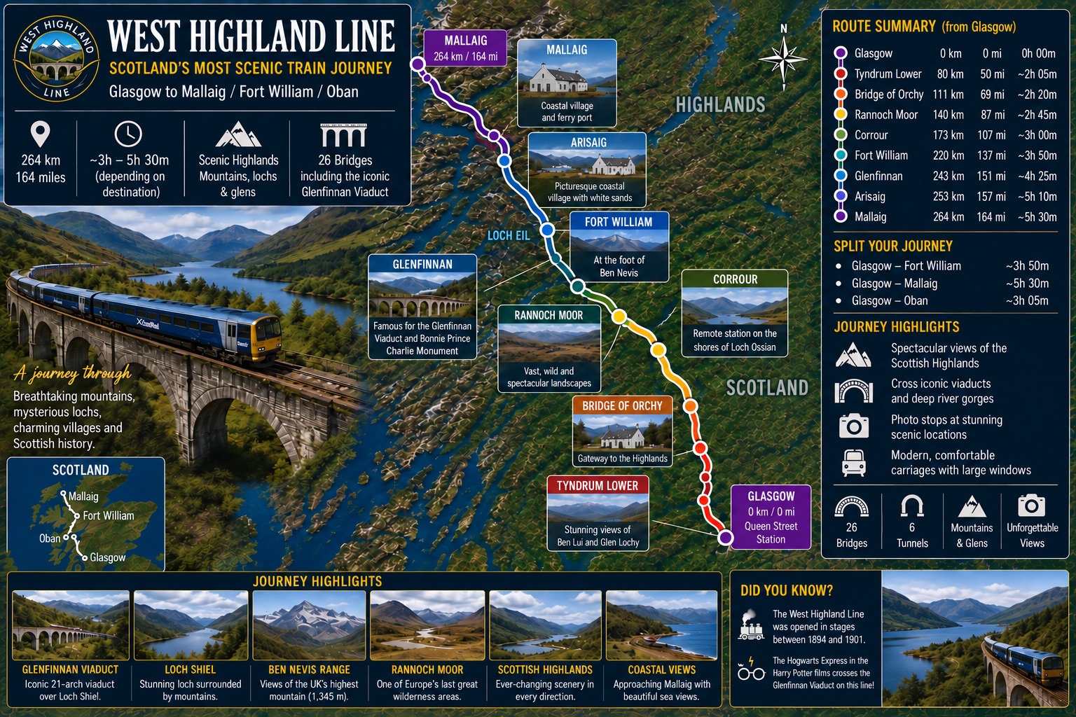
The route in text
- Route
- Glasgow ↔ Mallaig, Scotland
- Distance
- 164 mi / about 264 km
- Audio stories
- 26, narrated in both directions of travel, fully offline
- On the map
- Illustrated route map of the West Highland Line with stations, distances, and journey highlights. Station names and distance markers are printed on the map itself.
About this journey
Ride one of the world's great scenic railways from Glasgow to Mallaig on the West Highland Line. The train skirts Loch Lomond, crosses the vast emptiness of Rannoch Moor, and curves over the Glenfinnan Viaduct — the arc made famous by the Hogwarts Express — before reaching the silver sands and island views of the Atlantic coast.
Stops along the way
The stations the narration is keyed to, in order (toward mallaig). Timetables and stops change; check the operator before you book.
- Glasgow Queen Street
- Dalmuir
- Dumbarton Central
- Helensburgh Upper
- Garelochhead
- Arrochar and Tarbet
- Ardlui
- Crianlarich
- Upper Tyndrum
- Bridge of Orchy
- Rannoch
- Corrour
- Tulloch
- Roy Bridge
- Spean Bridge
- Fort William
- Banavie
- Corpach
- Loch Eil Outward Bound
- Locheilside
- Glenfinnan
- Lochailort
- Beasdale
- Arisaig
- Morar
- Mallaig
Highlights and which side to look
A few of the 26 narrated sights, toward mallaig, with the side of the train they appear on. See every sight, both directions.
| Distance from start | Sight | Look |
|---|---|---|
| 15 mi (25 km) | Dumbarton Rock | Left side |
| 101 mi (162 km) | Loch Treig: The Lonely Water | Left side |
| 127 mi (204 km) | Loch Eil & the Road to the Isles | Left side |
| 137 mi (220 km) | Glenfinnan Viaduct: The Wizard's Bridge that Concrete Built | Left side |
| 137 mi (221 km) | Glenfinnan: Where a Rebellion Began | Left side |
| 150 mi (241 km) | Loch nan Uamh: The Prince's Shore | Left side |
| 159 mi (256 km) | Loch Morar: The Deepest Water | Right side |
How the app works on this route
- Stories are triggered by GPS as you reach each place, so nothing depends on a signal or a timetable.
- Every story has a version for each direction of travel, and the narration says which side to look.
- Download the journey once at home; everything then works offline, including photos and the route map.
- The first three stories are free to listen to in the app before you buy.
- Narration keeps playing with the phone locked, so you can watch the window instead of the screen.
Questions about the West Highland Line
- Which side of the West Highland Line should I sit on?
- Toward Mallaig: 1 on the right, 6 on the left, 19 on either side. The app tells you which way to look for every story as it plays, so either seat works; the full list for both directions is in the window guide.
- Does the audio guide work without signal?
- Yes. Download the West Highland Line once at home and every story, photo and map works offline for the whole ride. Stories are triggered by GPS, which needs no signal.
- Does it work in both directions?
- Yes. Every story has a version for each direction of travel, and "left" and "right" are given relative to the way your train is moving.
- Can I try it before buying?
- Yes. The first three stories of the West Highland Line are free to listen to in the app, with their photos. The full journey is a one-time $4.99 purchase, or the Rail Journeys Pass ($29.99, one-time) covers every journey, including future ones, for life.
Sources
Route distance (164 mi / about 264 km): the operator's published figure — scotrail.co.uk. Stops and sights: the app's own route data, as rendered in the window guide.


